Hiking El Capitan, the largest single granite rock on earth, was one of the biggest highlights of our trip to Yosemite National Park. This 16 mile route took us past Yosemite Falls and through some beautiful forested Yosemite backcountry.
El Capitan is the largest single granite rock in the world and was one of the biggest draws for us to visit Yosemite National Park. There are two hiking routes to the top of El Capitan. We took the route from Yosemite Valley starting at Camp 4 as it is the more interesting route and gives the option to visit the top of Yosemite Falls. We climbed what seemed like a never ending rock staircase to Yosemite Falls, then made our way over to El Cap. The total hike was 16.4 miles and about 4,500 feet of elevation gain, almost 3,000 of which came within the first 3.2 miles of the hike.
To beat the heat, we started hiking in the dark at 5am. We parked in the lot across the street from Camp 4 because it does not require any permits and also has bathroom facilities. From there, it was really easy to cross the road and start from Yosemite Falls Trailhead. If you hike this, don’t make the mistake of starting at Lower Yosemite Falls Trailhead – that will only take you below the falls, not to the top to connect with the trail to El Capitan.
Upper Yosemite Falls
Our headlamps guided us through the darkness as we started up Yosemite Falls Trail. The first 3.2 miles of this hike are almost exclusively rock stairs, with just a few sections of flat trail in the middle. We climbed switchbacks back and forth steadily for about a mile and then caught the first views of the day at a little overlook. The sun was just beginning to rise, lightening the sky so we could see the silhouette of Half Dome over Yosemite Valley.
Starting in the dark
Hiking by headlamp
Switchbacks before sunrise
Half Dome at sunrise
The trail started getting a bit sandy, with small grains of dirt and dust covering some of the stairs, making it a little slippery, but still manageable. We continued going up rock stair switchbacks until we met a relatively flat section and saw our first stop of the day, Yosemite Falls, above us. Unfortunately, the water flow was not as strong as usual due to the immense drought in California. But, it was still incredible to stand underneath this massive cliff face and know that we were about to hike up to the top of the falls.
Rock stairs on Upper Yosemite Falls Trail
Yosemite Falls
We entered a section of trail that was more shaded by the trees and the bugs really started to swarm us. Not sure if it was just this section of trail or the time of day, but we moved very quickly to get away from all of the nagging and biting bugs. We emerged from the trees and could see that the rock stair trail headed directly up the center of a cleft in the cliffside. Seeing exactly where we were hiking really helped motivate us in the last mile of steady rock stairs. While it was difficult, this trail was really fun and incredibly beautiful – made even more special as the morning sun lit up the cliff face with glowing orange hues. After finishing the climb, we were really proud of how strong we felt. At the top, we turned right at the trail juncture and made our way over to Yosemite Falls on Upper Yosemite Falls Trail.
Climbing the last mile of rock stairs
Cliffside glowing in the morning sun
Yosemite Falls sign
To get to the falls, we descended some large rock stairs and then made our way down a very narrow path, holding onto a metal handrail to a rock platform enclosed with a metal fence. From there, we caught views across Yosemite Valley to Sentinel Dome, one of our previous day’s hikes with maybe the best views of our whole trip, and got super close to the top of the falls. We relished being the only ones at the top of the falls still so early in the morning.
Stairs and handrail down
Rock platform atop Yosemite Falls
Top of Yosemite Falls
View from the top of Yosemite Falls
Continuing to El Capitan
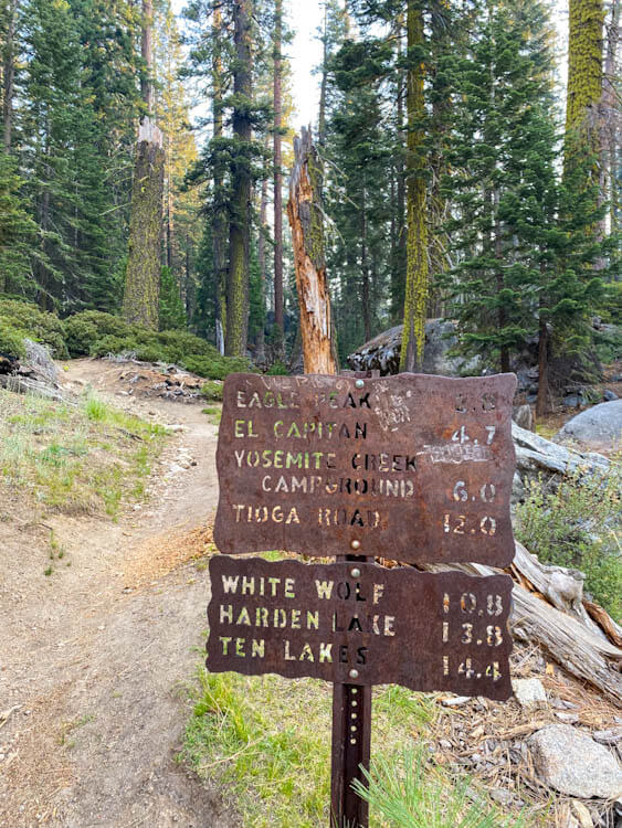
Knowing that we still had 13 miles more to hike, we went back to the juncture and continued on the trail following signs toward Eagle Peak and El Capitan. After the juncture, the landscape completely transformed. All of a sudden, we were walking on dirt trails surrounded by tall trees. We gained a bit more elevation, then the trail flattened out and we meandered through a couple of miles of beautiful wooded areas.
Trail sign by Yosemite Falls
Beautiful wooded trail
Then, we came to the juncture for Eagle Peak, where apparently there is an incredible view of the valley. Wanting to get to the top of El Cap, we decided to skip the half mile trail to the view and continue on to our primary destination. Just after the juncture, we lost a fair amount of elevation, dropping down into the woods. Then, we began climbing again, skirting a mountain, then popping in and out of wooded areas and more open rocky sections. Unfortunately, during this entire part, the bugs were absolutely terrible. It was extremely hot with the sun rising overhead and we were just swatting insects away from our face left and right. We definitely swallowed a couple too.
Descending further into the woods
Open rocky section
Then, we made it to the end of the treeline and in front of us we saw an entirely open rocky field shining under the hot sun. Emerging from the trees, we really started feeling the heat of the day and smelling the strong odor of the wildfire smoke. It felt like we were hanging over a campfire; it was so strong! All that smoke also made for a very hazy day, obscuring some of the incredible views from the trail and the top of El Cap.
Hiking over open terrain
Hazy view back toward Half Dome
Final stretch to the top
Atop El Capitan
When we finally made it to the top of El Capitan, we were both sweaty messes – hot and tired from the sun exposure over the last mile or so. But we were also overjoyed to know where we were standing! We enjoyed the moment, took some pictures, and rested for a bit under the shade of a tree.
Made it to the top of El Capitan
Filled up by views like this
Once we recovered from the heat, we decided to walk down toward the edge of the cliff. Like most high points around Yosemite Valley, the top of El Capitan is domed. In fact, it felt like a really flat open rock landscape in some areas so you can walk down a moderate grade toward the edge where climbers would finish scaling the granite wall. We jokingly looked for where Alex Honnold might have finished his Free Solo climb. After walking as far as we cared, we returned to the top, took in another view of Half Dome in the hazy distance, and prepared to head back to the valley floor.
Open top of El Capitan
Half Dome in the haze
Looking down toward the edge
As far as we went toward the edge
Descending
For the route back, we retraced our steps and made pretty quick time through the forested section to the top of Yosemite Falls. The sun was beating down and really made the green hues of the foliage and moss shine. On a quick logistical note, there is a little seep spring shortly before the top of El Capitan where hikers could refill water. We wouldn’t really count on it because of the drought and carried all the water we needed from the beginning. It was almost dry, just a little wet muddy spot next to the trail when we passed it.
Returning through open sections
Small seep along the trail
Walking through the forest
From the top of Yosemite Falls, it was 3.2 miles down the steep rock stair switchbacks back to the valley floor. By this point in the day, now just after noon, it was sweltering! We could feel the heat radiating off the baking rocks underfoot and the cliffside. And there were so many hikers just heading up the trail – we were so glad we started this hike as early as we did. It would have been a lot more difficult with such heat the whole way. We enjoyed the great views of Yosemite Valley and Yosemite Falls, now in full daylight, feeling good, but also tired and hot and ready to be done.
Yosemite Valley sign
Descending the top of the switchbacks
Yosemite Falls
View of Yosemite Valley
Steep switchbacks on Upper Yosemite Falls Trail
El Capitan Meadow
We finished this epic hike with plenty of time left in the day to relax and recover. We opted to cool off in the Merced River by El Capitan Meadow and really enjoyed looking up at where we just hiked with a huge sense of accomplishment.
Since we loved the views from El Capitan Meadow so much, we decided to come back there the next morning to take pictures around breakfast time as the sun was coming up. Here are a few highlights:


Be First to Comment