Hiking the Appalachian Trail Through Southern Virginia
Entering completely new territory, we weren’t sure what to expect in southern Virginia. But, with great challenges come great rewards. The terrain and climbs in this section were harder, but the views and experiences were worth it. We hiked the famous Virginia Triple Crown, had one of our best Hostel experiences at Woods Hole, made more solid connections with SOBO hikers, saw wild ponies in Grayson Highlands, stayed in Damascus (a popular trail town), and really revitalized our focus on mindfulness and meditation for the first time since Maine. The trails felt more remote and more immersive. We’re still moving and still growing day by day.
Big Reflections:
- This section of the AT has felt more wild and remote than most of the mid-Atlantic, which provided the space for us to return to our focus on mindfulness and meditation. The trail itself, with less people, noise, and distraction, has lent itself to more reflection and introspection. We’ve both focused on cultivating our deepest intention and discussed how we can move from those places on a daily basis. Along with that, the connections between our minds, bodies, and nature are strengthening. We feel in our bodies when we’ve hiked a certain number of miles. We sense when a climb is about to end or begin based on the terrain. And we live with the rhythms of the natural world. It’s a really good life out here.
- This section of Virginia became more mountainous and more challenging. Whoever said Virginia is just fields and pastures was lying! There were tons of climbs and plenty of rocks. With the increased difficulty of the terrain, we both experienced challenge in finding balance between our desires to slow down, be present, and remain responsive to our bodies while also pushing our physical limits or finding states of flow. After hiking over 1500 miles, our bodies are able to hike really long days but we also feel the cumulative wear and tear of this thru-hike. For Lotus, it’s general fatigue and wanting to sleep more. For Stretch, it has been nagging hamstring and Achilles heel soreness. We are both paying attention to our bodies and slowing down when needed. That said, a big part of long distance hiking just includes coping with physical discomfort.
- The daylight hours are getting shorter and shorter, the evenings and mornings colder and colder, but the hiking days have been so pleasant. We aren’t sweating through our clothes; we feel cleaner; and we feel less depleted. Also, the fall foliage has been spectacular. These are just the trade-offs of hiking at this time of year and we are so grateful to be out here!
- Body transformation: we’ve gotten a lot of questions about what changes we’ve noticed in our bodies, specifically in terms of weight loss. Neither of us entered this hike with a goal of losing weight. We just wanted to feel healthy and strong, which we have. That said, yes, both of us have lost weight, In the first couple of months, Lotus gained muscle and lost fat, which pretty evenly offset. About halfway through, though, her hiker hunger kicked in and in Virginia, she weighed herself and found that she was down about 10lbs. Stretch actually gained back weight after losing about 10lbs early in the thru-hike. He has added protein powder to his daily regimen to help his muscles recover and rebuild. Both of us have increased our caloric intake and are thinking about how we can maintain healthy body compositions through the finish.
Day 109, 10/4/22: Lamberts Meadow Campsite to Campsite before Dragon’s Tooth
17.3 mi, 4200 ft elevation gain
Exhausted from the long day yesterday, we let ourselves sleep in and did not start hiking until about 9am. The climb to Tinker Cliffs, one of the Virginia Triple Crown highlights, was very mild and quick. Then we walked the curving ridge to McAfee Knob, another highlight of the Virginia Triple Crown and the most photographed location on the Appalachian Trail. When we reached an open view, we initially couldn’t tell if we were there. But then just around the corner were a bunch of day hikers and the obvious ledge. After chatting with an aspiring thru-hiker, we did our photoshoot and moved on. The descent was reasonable, but we felt super tired on the next climb and extremely long switchbacked descent. In the last few miles we walked through farm fields with some grazing cattle pretty much right on the trail. The scenery was also super pretty from then on. We walked 0.3 mi off trail to resupply at a gas station and eat pizza. The road walk felt long, but any opportunity to get town food is worth the effort. Heavy from dinner, we trudged up the road and less than a mile to a tent site just off trail. It was a super windy and cold night and we were glad we didn’t have to cook.


Day 110, 10/5/22: Campsite before Dragon’s Tooth to Sarver Hollow Shelter
21.9 mi, 5500 ft elevation gain
At 5:30am, our alarms went off to wake us up for a sunrise from Dragon’s Tooth, one of the Triple Crown of Virginia highlights. Tired from the last two days of hiking, we decided to sleep in another hour and forgo the sunrise. It’s important to listen to what our bodies need. We were proud that we were able to put that wisdom into practice today. At 3.5 months into this thru-hike, we’re just really fatigued and need the time for rest and recovery each day. We started hiking around 8am and the morning sun over the mountains was majestic. There were a few different viewpoints along the climb, which was the rockiest and most challenging one we’ve had since Maine. At the trail juncture along the ridge, we ran into Big Catt, Marshall, and Swift. We hiked the short spur trail to Dragon’s Tooth, climbed as far as we safely could, then sat on the rocks absorbing the sun and the views for almost an hour. After, we descended and then ascended another mountain and then another. The elevation gain was pretty sizable today and we were definitely feeling it in our bodies. The last push of the day got us to the top of a ridge on the Eastern Continental Divide. This traversed treacherous terrain with some rocky outcrops with views of the mountain spines up and down the valley. In the slanting light of late evening each contour showed clearly lined with shadows. To get to the shelter, we unfortunately had to hike a steep 0.4 mi downhill and navigate around many blow downs. Adding mileage and elevation at the end of a long day is never pleasant. The ground was not very level, the water source was even further down, and we ate in the dark. This was a tough one! But every day ends with us laying down in relative comfort. So it was a pretty good day overall – filled with lots of beauty and another trail day to remember.


Day 111, 10/6/22: Sarver Hollow Shelter to Big Stony Creek
22.8 mi, 4800 ft elevation gain
We got a later start today. The 20+ mile days are starting to get to us and we are just plain tired. After climbing up from the shelter, we enjoyed a ridgeline walk in the warm sun before descending. We emerged from the trees to walk through expansive rolling farmland and fields. The reeds and trees were a burnt red color, showing the first real signs of fall. This was one of the most beautiful sections and reminded us a lot of our Camino in Spain. Just outside a pasture we passed by the Keffer Oak, the 2nd largest on the trail and largest in the south. Stretch had to give it a big hug. Past the farms in the woods Stretch got stung by another yellow jacket. He’s sadly used to this by now but we had hoped he would be luckier. The climb up Kelly Knob was pretty difficult on both of us. We stopped more than we usually do and were surprisingly fatigued. At the top, we took a short blue blaze to some mostly overgrown ledges for lunch. After a short ridgeline we descended and passed through thick rhododendrons that gave the trail a jungle feel. We climbed into Mountain Lakes Wilderness and traversed a ridge in the late afternoon light pausing at Wind Rock for views of the newly changing leaves. They’re still muted from a distance with only certain trees in the foreground popping with color. The second half of this ridgeline was much rockier and took more effort and concentration to make careful steps. We were tired and felt the consistent big mile days taking a toll on us (plus Benadryl to treat the bee sting did not help Stretch feel good today). We’ve felt good doing consistent 20+ mi days since PA, but it’s steeper here in the middle of VA. The elevation really adds up over the miles and there are more sustained climbs to wear us out. Moving forward, we might need to adjust to an 18ish mile average to feel good overall. We made it to camp around 7pm and set up quickly before the light vanished. We cooked in the last light and ate in the dark again. Just 1 more big day into Pearisburg for rest and resupply.


Day 112, 10/7/22: Big Stony Creek to Pearisburg, VA (stay at Angels Rest)
22 mi, ft 3950 elevation gain
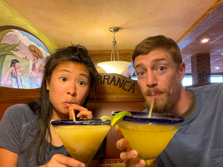
What a pleasant day. Today, we tried a new morning routine of heating our water up in the vestibule of our tent so we could have breakfast in our warm sleeping bags. It took some readjustment, but it was worth it. We stayed as warm as possible for as long as possible. The morning climb was lovely, full of long switchbacks and rising sun. For the next 11 miles, we hiked along the ridgeline, listening to podcasts and talking about the best and hardest parts of our thru hike. At one point, a bunch of goats came strolling towards us on the trail started licking us for the salts on our skin. The weather was gorgeous and we really enjoyed the terrain, especially after a few challenging days. The descent was fairly easy. Stretch stopped to identify tree types along the way while Lotus kept moving. Before we knew it, we hiked 13 miles before lunch and 22 miles by 3pm. Angel’s Rest Hostel picked us up along with Bears, another flip-flopper. We showered, did laundry, and went to a Mexican restaurant where we drank the largest margaritas we’ve ever seen with a bunch of SOBOs. Maybe it was the margarita or the general joy we were feeling, but Stretch decided to pencil roll down a hill to the Food Lion to resupply. Bears and Lotus could not stop laughing. Maintaining levity out here is important. The day ended with sitting around a warm fire on a cold night enjoying the community of fellow hikers.


Day 113, 10/8/22: Pearisburg, VA (stay at Angels Rest) to Woods Hole Hostel
11.5 mi, 3600 ft elevation gain
Sleeping in until almost 8am felt like such a luxury. We drank coffee/tea and reorganized our bags while chatting with Mischief, Homework, and Dunk in the indoor common area of the trailer and then hopped in a shuttle back to trail. It was a cold morning but we warmed up quickly with a big climb out of Pearisburg to Angel’s Rest viewpoint. As Derick Lugo described in his book The Unlikely Thru-Hiker, we felt like we became a part of a moving village of hikers walking in the same direction and stopping at the same spots. We were all on our way to Woods Hole Hostel, an iconic stop on the AT. By the afternoon, the bright yellow and gold leaves and ferns glowed in the autumn sun. It may be cold, but hiking through the fall has incredible upsides. The changing colors make the trail more interesting and dynamic than the typical “green tunnel.” The miles flew by as we listened to a book and meandered through the fall foliage until we got to the hostel, less than a mile down the road. Our experience at Wood’s Hole was truly magical. Somebody “trail magicked” our glamping tent, so we didn’t have to pay for it. It was equipped with a heated blanket and a heater for a night getting down into the low 30s. And the communal meal consisted of Mexican lasagna, bread, and salad with much of the food grown in their garden. We did a gratitude circle (a tradition at Woods Hole), shared our meal around the fire, watched the mostly full moon rise into the sunset sky, and then spent the night chatting with other SOBOs in a warm bunk room. This felt like a truly special AT experience.


Day 114, 8/9/22: Woods Hole Hostel to Jenny Knob Shelter
21.8 mi, 3200 ft elevation gain
As soon as we unzipped our safari tent, our mouths dropped. We were greeted by the most spectacular sunrise and undercast clouds in the valley. Lotus went to the main house to grab coffee and tea for us and we sat in our bed under our heated blanket to watch the sun rise on a new day. It is mornings like these that make us feel so grateful for this experience. We gathered in another gratitude circle before a huge breakfast of eggs with swiss chard, grits, and bread. After, we chatted with other hikers, most of whom succumbed to the vortex and decided to take a zero at Woods Hole. We warmed up in our fancy tent and then gathered our belongings to get hiking. On ideal hiking days like today, when the air is crisp and the sun is shining, we generally don’t want take a zero. We just wanted to hike! The fall foliage was really popping and everything was coated in golden and burnt orange hues. We are so excited for more colors as we hike further into autumn. And we know that the seasons are changing fast so the they might zoom past peak before we know it. Although we didn’t start hiking until 10:30am, we hiked almost 22 miles by 6pm. The terrain was so pleasant and we had an incredible day in the woods. Andy, a hiker at the shelter, gave us the rest of his bacon Gouda cheese (yum). Then, a group of about 10 college students on an outdoor weekend trip rolled in around 8pm, our hiker midnight. After today, we realized that we didn’t need to shorten miles overall, only on really challenging elevation and terrain days.


Day 115, 10/10/22: Jenny Knob Shelter to Hunting Camp Creek
23.2 mi, 4500 ft elevation gain
It was a cold night. Stretch slept with our water filters in his sleeping bag so they didn’t freeze when it got down to about 30 degrees. Lotus woke up multiple times, most likely because she was cold and her joints and muscles were tighter as a result. It definitely could have been worse, though. The next morning, we started hiking around 8:15am, which felt really good. It was light out but not too late. The morning miles passed very quickly. As per usual, there were a lot of ups and downs, skirting the sides of the mountains, and walking through tunnels of rhododendron bushes and orange and yellow trees. For about a mile, the AT turned into a road walk that brought us directly to a small grocery called Brushy Mountain Outpost. It had very limited resupply options, but did have hot food to order. Stretch got a burger with an inch thick slice of fried bologna on it. That thing was bigger than the burger! Wider by far and at least twice as thick. And always consistent, Lotus got chicken fingers and fries. We chatted with Unbound, a hiker who was doing the Eastern Continental Trail, which is the Appalachian Trail plus other trails that extend into Florida and Canada! Another outdoor club from Duke also stopped to ask us questions about our thru hike. They were so curious and excited and we really fed off their positive energy. We cruised through the last eight miles and camped in a valley surrounded by jungle-like rhododendrons. After a campfire and a yoga flow, we enjoyed dinner and crawled into our tent before 7:30pm.


Day 116, 10/11/22: Hunting Camp Creek to Knot Maul Branch Shelter
20.2 mi, 5000 ft elevation gain
It was very cold and dewy in the valley this morning, making it hard to get out of our tent. We let ourselves sleep in and didn’t start hiking until around 9am. Today was deceptively hard! We gained over 5,000 ft of elevation, but it didn’t come in sustained climbs. There were a few big climbs but most of it consisted of rocky ups and downs along ridgelines. Luckily, it was sunny and warm once the sun rose higher. The biggest single climb was up to Chestnut Knob, where a shelter and picnic bench overlooked Burke’s Garden – a whole valley formed by a miles wide sinkhole. The trail on the way up was a gentle dirt path surrounded by trees glowing yellow in the morning sun. We spent an hour on the summit, soaking in the warmth and allowing our bodies to rest after a challenging day of hiking already. A bit sleepy following our long break, we were relieved at the mildness of the descent, which took us over Chestnut Ridge. We loved the gentle open fields with expansive mountain views. It was nice to finally get some cruising miles for a short bit. In the late afternoon, however, we returned to climbing. The mountains had long spines with deep wrinkles. We hiked in and out of the wrinkles and up and down on the sides of the slope. We also had to cross a river that could require fording due to a bridge that was washed out. Luckily, it was rock hoppable for us so we didn’t have to get our feet wet. Tired, we were relieved that these final features of the day were less challenging than we expected. Towards the end of the day, we turned up the north slope where it was way chillier at the bottom in the rhododendron forest. The cold air must be settling there, so we climbed up to the shelter instead of camping down there. And it was indeed warmer a little higher up. We ended at the shelter with great tenting space and a perfectly sized picnic table for two.


Day 117, 10/12/22: Knot Maul Branch Shelter to Rt 11 (stay at Alpaca Farm Hostel)
14.7 mi, 3200 ft elevation gain
Last night was so much warmer. We woke up at 7:15am feeling like we could pack up without needing to huddle in our sleeping bags. Win! The first climb of the day was incredibly mild. After, we entered a stretch of rolling farmland and pastures wet with dew. Even though it didn’t rain, the dew made our feet damp, which is another discomfort we’ve had to deal with. The open views of the hillsides from these fields have been some of the best in VA so far. Even on a cloudy day, could see fall colors getting closer to around peak vibrance. Some oaks have already gone brown which dulled the overall view, but the reds were popping, especially up close. Perhaps even more beautiful were the yellow and red with golden ferns carpeting areas along the ridges. On the flip side, we’ve also seen more hunters, which has made Lotus feel a bit uneasy. We need to get some blaze orange to wear! Around lunch, we ran into Heat Lightening, a thru-hiker who we have actually met hiking in New Hampshire. The hiking world is quite small. Then, the big highlight o the day and the hike was was when we got to the ¾ of the way to Georgia sign! We were filled with such elation seeing this unexpected milestone today. How have we already walked over 1,600 miles? Time is flying and we are trying to soak up every moment on trail. When we stopped to reflect on how far we’ve come, we were overwhelmed and felt a good deal of melancholy as we know we’re getting closer to the end of this experience. We got to the road and resupplied at Sunoco and Exxon before heading to Long Neck Lair, an alpaca farm that offered housing for hikers. It’s actually impressive that we can pull off 4 days of food from gas station mini marts. We honestly didn’t know if we’d have it in us. But we don’t prefer hitching or arranging rides to bigger towns when we can walk right along or just off trail to places. Walking up the gravel road to the hostel, we were greeted by alpacas, farm cats, and chickens! Then, we cooked pasta in the common bunk room. After our dinner and beers outside with Heat Lightening, we retired to enjoy our very nice private room, a luxury on the AT! The balance of social time and alone time at hostels has been really important for our happiness and relaxation.


Day 118, 10/13/22: Rt 11 (stay at Alpaca Farm Hostel) to Trimpi Shelter
21.4 mi, 4500 ft elevation gain
When we woke, we were pleasantly surprised that it was not raining as forecasted. Stretch made pancakes and oatmeal (provided by the alpaca farm for hikers) to fuel us for a big day. We left around 9:30am and walked the road back to the trail in some spitting mist that disappeared as we wound around the back of the farm. We stopped into an old one room schoolhouse from the 1890s just off trail and saw OB and Marco. There was also an awesome hiker box full of food there and we signed the chalkboard as other hikers had done. The first half of the day was challenging, with lots of dead leaves obscuring the jagged rocks on the trail beneath a uniform carpet. So we had to feel our way into steps and kicked many of them along the way. It felt like Pennsylvania 2.0! Our feet and knees definitely felt the strain of the careful steps we had to take and the heaviness of our packs after a full resupply for 3.5 days. But the tough moments out here seem to pass quickly. Our flow and happiness are more sustained than any of the difficulty or discomfort. It drizzled slightly on and off through the morning, but mainly stayed cloudy with unrealized threats of full rain. The second half of the day was much more pleasant. The sun peered through the trees periodically and the fall colors were at their peak! Up top, we were in a cloud layer walking through a misty yellow forest. At lower elevations we passed through rhododendron forest. Some of the more picturesque scenes are provided by the tunnels cut for the trail through the thick stands, many of them resembling subway tunnels. It also sounded and smelled like fall: dead leaves crunched under our feet and the musty smell of decaying mushrooms and leaves filled the air. This brought back memories of raking leaves as a kid – crafting that perfect pile to jump into and scatter everything into chaos. We stopped at a viewpoint and many times through the cow pastures to admire the foliage before settling in at camp. As we get closer to Georgia each day, we are feeling the enormity of what we are doing and cannot believe how much we’ve already accomplished.


Day 119, 10/14/22: Trimpi Shelter to Grayson Highlands Campsite
24.4 mi, 6300 ft elevation gain
Today was a long day but ended in some of the greatest highlights of Virginia so far: wild ponies in the Grayson Highlands! The first half of the day was really pleasant. Even though we gained a lot of elevation, the climb was gradual as the trail snaked around the outskirts of the mountains rather than going straight up. The leaves were bright yellow and the morning passed quickly. The second half of the day included more difficult climbs with steeper rocky inclines over successively higher rises as we gained elevation toward the Grayson Highlands. Once at higher elevation, above 4,000 ft, the landscape changed dramatically. We went through a section of conifers, then open pastures with scrubby bushes and grazing cows. When we entered Grayson Highlands State Park, we were blown away by the views even though it was past foliage peak. Wilburn Ridge included some rocky peaks between grassy meadows across which the wind whipped and bit with cold. We timed this well and were traversing the section as the golden evening hours approached and the last light of the day cast deep long shadows between the trees. And, we saw our first wild ponies! At a viewpoint by Pine Mountain we took in Mt. Rogers, the VA state high point, as the sun set behind its shoulder. Shortly down the trail through thick twisty rhododendrons we found the spot labeled “many campsites.” This was an understatement by far. There were already so many tents set up so we walked past them out toward the open mountaintop meadow. We found a nice spot looking out into the meadow and the bear box. Just next to our tent spot were wild ponies grazing and running! It was a remarkable experience. It got super cold for dinner, but the sunset was gorgeous and then the stars came out on a crystal clear night, even the Milky Way became visible. It all made for a magical evening.


Day 120, 10/15/22: Grayson Highlands to Saunders Shelter
19.8 mi, 3100 ft elevation gain (+1 mi for Mt. Rogers)
It was extremely cold and windy this morning. We woke up to our tent rattling from the wind and decided to stay in our warm sleeping bags and get a late start. The sun’s warmth drew us out of the tent slowly. Stretch savored time for morning meditation and connected with the natural splendor of this place. Eventually, we started hiking around 9:45am. We decided to add an extra mile to the day to hike up to Virginia’s highest point, Mount Rogers. That spur trail gained just a couple hundred feet of elevation through a nice conifer forest, the likes of which we hadn’t seen since New England, and ended at a wooded summit with no view whatsoever. After, we hiked over an undulating trail and passed more day and weekend hikers than we have seen this entire thru! It seems like everyone wanted to go to the Grayson Highlands. After lunch in a windy open field, we crossed a road at a huge parking lot and continued south on the AT where we saw way less people. Honestly, Lotus was lagging for the first part of the day, most likely because she was so tired from the long day yesterday. The sweeping views from Buzzard Rock of intense burnt orange fall foliage provided enough rewards to help her get through the second half of the day, which consisted mostly downhill on tough slopes with rocks hidden under the fallen leaves. This has been an added challenge over the past week and especially the last couple days. It was a lot of work on our ankles to step carefully while contending with the sideways slant of the path on descending switchbacks. Once down, we briefly crossed a pasture with a golden maple starting to burn red standing magnificently on a hillside in all its fall foliage glory. We couldn’t help but stop and marvel for a little bit. Then we reached the Virginia Creeper Trail. It was very flat for easy walking, but unfortunately shared the trail with bikers – veritable hordes of them ringing bells and calling “on your left” as they swooshed past. Many did not inspire confidence as they wobbled on two wheels and we were grateful to avoid being clipped by anyone. Then, we climbed in the last four miles to the shelter. There were 2 pairs of lovely section hikers/backpackers there already and talking with them really lifted our spirits on a night that we could have just collapsed and been total zombies. Another warm night or AT community – it’s not only thru-hikers who bring that. Thank you Rocky, Tumbleweed, Falcon, and Masta P!


Day 121, 10/16/22: Saunders Shelter to Damascus, VA
8.5 mi, 1340 ft elevation gain
Damascus is known as “Trail Town USA” because many trails intersect there, it is home to Trail Days, and is also the first town in Virginia for NOBOs and the last for us SOBOs. We only had 8.5 miles to hike this morning (yes, we are aware of how ridiculous it sounds to say “only”), so we got to town by noon before the rain started. We hiked down switchbacks descending a steep open forested hillside and then through denser forest under peak fall foliage. Instead of a green tunnel, we’ve had a yellow and orange tunnel recently. On the way to town, we passed Wolfram (who we met the day before), Falcon, and Masta P. One of them reminded Lotus that a Lotus is not only a growing flower but also an awesome F1 racing car! She is a fast hiker so we love the double meaning of her trail name. When we rolled into the Broken Fiddle Hostel, we were greeted by Tick Bite, who we hadn’t seen in a couple of weeks! Lotus got her last pair of shoes and threw her old shoes up in a tree at Boots Off (on the first try, she wants everyone to know). Then, we saw No Kiddin, who we hadn’t seen since Harpers Ferry! Slowly, more hikers we knew rolled in: Ducky, Gravy, and Wolfram. Reuniting with hikers we haven’t seen in a while is such a beautiful part of the trail. We drank beer and played darts together before going out to dinner. together We even ran into Rocky and Tumbleweed at dinner! All in all, this was a great way to finish our time in Virginia. Knowing that we only have 3 states left is bittersweet and we are really beginning to process what it will mean to finish this thru-hike in less than a month.


Be First to Comment